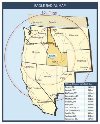
Eagle has direct connection to Interstate-84 via Eagle Road/State Highway 55. The Boise airport is a short 23-minute drive via Interstate-84 from Eagle Road/State Highway 55. Aerial connectivity from the Boise Airport is convenient for companies needing direct nonstop flights. The Boise Airport is served by seven major airlines with nonstop flights to 21 cities and counting.
Getting around the Treasure Valley is easy with one major interstate (I-84) serving the entire metro area, and with federal highways 20,26, and 30, and state highways 21,44 and 55 providing access to communities across the Valley.
Eagle is located directly off Eagle Road, which is a main thoroughfare that connects directly to Interstate 84. In addition, state highway 44 runs in an east-west direction through Eagle connecting to state highway 55 and highway 16.
Highway 16 begins at the junction of US-20/US-26. It meets at a junction with State Highway 44, with Star to the West, and Eagle to the East. This highway is proposed to be extended south to Interstate 84.
The Idaho Legislature has authorized funds to begin construction in the Summer of 2022. Initial construction will include:
The US-20/ US-26 corridor is one of the few east-west commuter routes that connect to I-84 in Boise all the way to I-84 in Caldwell, traveling directly through Eagle. The road is currently a two-lane, suburban, and rural roadway; however, studies are being done to determine the need for future right-of-way and recommended improvements between now and 2040. If these improvements are approved, the highway would be widened to a six-lane divided highway from Eagle Road west to Interstate 84. The plan would be to do this in phases, with a widening to four lanes between 2021 and 2032 and six lanes by 2040.
State Highway 44 starts at the junction of Interstate 84 north of Caldwell. The highway heads eastward staying mostly to the north of the Boise River. The highway goes through the cities of Middleton and Star, meeting its junction with SH-16. Highway 44 continues east through Eagle and intersects with State Highway 55. From Eagle eastward, the highway is also known as State Street and continues toward Boise before ending at US-20/US-26.
State Highway 55 is an Idaho highway from Marsing to New Meadows, connecting with US-95 at both ends. US-95 starts with the junction of US-95, approximately two miles west of Marsing. The highway heads eastward to Nampa, where it meets Interstate 84 and US-30. The highway is cosigned with those routes as it heads eastward to Meridian. Highway 55 turns northward at Eagle Road and crosses the Boise River. East of Eagle, Highway 55 turns northward and climbs over the Spring Valley Summit into Horseshoe Bend and continues through until it reaches US-95 in New Meadows.
Air Service for Eagle is provided by Boise Airport (BOI), located 15.4 miles from Eagle. The Boise Airport handles more than three million travelers each year and is served by major airlines which offer several nonstop flights to major destinations with connecting flights to thousands of cities worldwide.
Runways: The Boise Airport has two parallel runways, 10R/28L and 10L/28R. The primary instrument runway, Runway 10R/28L is 9,763 feet long and 150-feet wide. The runway has a category III instrument Landing System with minimums to 400 feet visual range. This gives the Boise Airport one of the safest and most efficient landing systems in the nation. Runway 10L/28R is 10,000 feet long and 150-feet wide.
General Aviation: FedEx and UPS both operate out of the Boise airport providing access to fast shipping. In addition, almost 50 motor freight trucking companies, 30 air freight and package express companies, and several air courier services operate from the facility. Learn more on the General Aviation page of the Boise Airport website.
Public Transportation is provided by ValleyRide (Valley Regional Transit) and Commuteride (Ada County Highway District). ValleyRide provides public bus transportation throughout the Boise Valley and Commuteride provides van and carpooling services in the area.
Alternative Transportation is provided by the Boise River Greenbelt. The Boise River Greenbelt connects cyclists, joggers, and walkers to downtown Boise. The greenbelt has expanded public access and enjoyment of the river, including opportunities for kayaking, fishing, paddle boarding, and other river-based recreation.
The furthest that sea cargo can transit into the western coast of the United States is located on the Columbia River at the Port of Lewiston, Idaho. The port has full intermodal capabilities and provides the largest crane, warehouse, and grain storage facility on the inland river system.